
Saturday Worldbuilding is a weekly project wherein yours truly builds a world from scratch in a disorganized bid to express what I think makes a world useful and interesting.
Advocates for Tolkien’s style of worldbuilding say you ought to start with a map. I say that’s nonsense, but I won’t say maps aren’t useful. There are a metric ton of mapmaking tools available online, and I’ve tried many of them.
If you’d like something randomized, Azgaar’s Fantasy Map Generator is a pretty impressive tool. Over the last year, I’ve started using the free version of Hexographer/Worldographer to satisfying results. I’ve also tried out ProFantasy’s Campaign Cartographer tools. They’re quite extensive, but I haven’t found them to be intuitive. I’ve played around with the free version of Inkarnate to mixed results, and there’s also Hextml, a web-based hex map tool.
And of course, lots of creators have mapmaking advice. The Alexandrian and Matt Colville both offer lots of useful mapmaking and worldbuilding advice (no surprise). Questing Beast and WASD20 both offer tons of useful advice on mapmaking. I find WASD20’s 10 Rules for Believable Fantasy Maps super useful.
For my more polished maps, I use approximately the same process that Dael Kingsmill lays out in the video below, except because I’m a menace with a pencil, I use Hexographer to build the bones of my map.
I’m going to keep things pretty simple. I’m going to throw together a hex map. The scale is about 24 miles to the hex so each hex is about a days travel. This is a small kingdom conforming (roughly) to medieval norms, so I’m going to say it extends out about 100 miles in any direction from the capital. We’re based in coastal swamps, so I’ll throw in some islands. We’ll want a river to feed into our swamps. Cities like rivers. And rivers flow downhill so probably we’ve got some mountains on one edge of our map.
It took me about 30 minutes. I haphazardly dotted in some villages, ruins, and other points of interest, and now we’ve got quite a few sessions worth of map to fill in and explore.
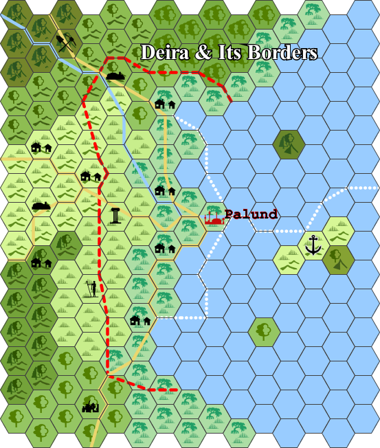
Something else I’ll probably do is a quick, flowchart style map of Palund itself. I believe Colville suggested this in a video, though I haven’t had the time to dig through and find it.
A good map is useful, but what you need to know most can be written down in bullet points. Like so:
- Capital is Palund, centered in a swamp. The next closest village is Waylund, a days journey through the mud to the west.
- 72 miles over sea to the east is a port town on a large island.
- Three days inland, there is a monument, perhaps a tomb, that is often considered the border marker.
There you have it. Quick and dirty, that’s how I handle maps. Next time we’ll talk ancestries (fantasy races), and we’ll inch closer to finishing this project.
